


Satellite-ASIGN
คำอธิบายของSatellite-ASIGN
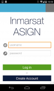
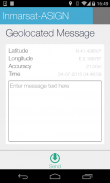
Satellite-ASIGN is an experimental version of UN-ASIGN for crowdsourcing geo-referenced photos, text and disaster needs forms via satellite communications. The intention is to share the data for free with the international humanitarian disaster management community, United Nations, Civil Protection.
Using this App, the communication cost over satellite would not need to be covered by the users of the App. General rights to the photos belong to the users, but Inmarsat is given the rights to share with users and organisations related to this cause. Specifically the observations will be offered to the UN, for integration into live satellite maps.
Satellite-ASIGN offers interactive mission-critical visual communications capabilities with geo- and time-tagged photos, where users first send a small preview of a photo, that can be assessed for operational relevance. If and as needed, selected content can later be interactively fetched from the original photos contained within the App.
ดาวเทียม ASIGN เป็นรุ่นทดลองของสหประชาชาติ ASIGN สำหรับ crowdsourcing ภาพถ่ายอ้างอิงทางภูมิศาสตร์ข้อความและภัยพิบัติที่ต้องการรูปแบบที่ผ่านการสื่อสารผ่านดาวเทียม ความตั้งใจที่จะแบ่งปันข้อมูลฟรีกับชุมชนจัดการภัยพิบัติด้านมนุษยธรรมระหว่างประเทศแห่งสหประชาชาติคุ้มครองพลเรือน
ใช้ app นี้ค่าใช้จ่ายในการสื่อสารดาวเทียมจะไม่จำเป็นต้องได้รับการคุ้มครองโดยผู้ใช้งานของ App สิทธิทั่วไปให้กับภาพที่อยู่ในผู้ใช้ แต่ Inmarsat จะได้รับสิทธิในการมีส่วนร่วมกับผู้ใช้และองค์กรที่เกี่ยวข้องกับสาเหตุนี้ โดยเฉพาะข้อสังเกตที่จะเสนอให้สหประชาชาติสำหรับการรวมเข้าแผนที่ดาวเทียมสด
ดาวเทียม ASIGN มีภารกิจที่สำคัญความสามารถในการสื่อสารภาพการโต้ตอบกับภาพถ่ายทางภูมิศาสตร์และเวลาที่ติดแท็กที่ผู้ใช้ครั้งแรกส่งตัวอย่างขนาดเล็กของภาพที่สามารถประเมินความสัมพันธ์กันในการดำเนินงาน และถ้าได้ตามต้องการเนื้อหาที่เลือกในภายหลังสามารถโต้ตอบเรียกจากภาพต้นฉบับที่มีอยู่ภายใน app
Satellite-ASIGN--เวอร์ชั่น1.2.6
(10-06-2023)Satellite-ASIGN - ข้อมูล APK
เวอร์ชั่น APK: 1.2.6แพ็คเกจ: ansur.asign.inmarsatเวอร์ชั่นล่าสุดของSatellite-ASIGN
เวอร์ชั่นอื่น


แอปในประเภทเดียวกัน
 4.484.274.334.24


